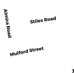
8 MULFORD ST
Owner Information
NORRIS KATHERINE M
8 MULFORD ST
SOUTH YARMOUTH, MA 02664


Property Details
8 MULFORD ST is classified as a Single Family Residential (Ranch).
The primary structure on this property was built in 1967. There are 3,408ft2 of built area within this property. There is 1,264ft2 of residential/living space within this property. This property is listed as having 4 rooms.
8 MULFORD ST is valued at $353,200. The land is valued at $120,000 and the structures are valued at $231,500. There is an additional valuation of $1,700 on this property.
The most recent deed for 8 MULFORD ST is recorded at the local registrar in Book 30003, Page 74. 8 MULFORD ST was last sold on Thursday, October 13, 2016 for $310,000.
Assessment data from fiscal year 2022.
Flood Data
According to the FEMA National Flood Hazard Layer, this property does not appear to be in a flood zone. It may also be in an area not yet reviewed. Nonetheless, confirm this information prior to taking any action.
To view the flood hazards around this property, create a FEMA "Firmette" Map of the area around 8 MULFORD ST.
Broadband Internet Providers
| Provider | Type | Bandwidth (mbps) | |
|---|---|---|---|
| Viasat Inc | Satellite | 35 | 3 |
| Comcast | Cable | 1000 | 35 |
| Verizon New England Inc. | DSL | 5 | 0 |
| VSAT Systems, LLC. | Satellite | 2 | 1 |
| HughesNet | Satellite | 25 | 3 |
| GCI Communication Corp. | Satellite | 0 | 0 |
Broadband service provider data from December 2020.
Adjacent Properties
- 15 STILES RD
Single Family Residential owned by JACKSON NANCY - 14 MULFORD ST
Single Family Residential owned by BOWSER BRIAN L - 9 STILES RD
Single Family Residential owned by CAMERON ANDREA D - 1 STILES RD
Single Family Residential owned by REDDING BETTY J TR - 2 MULFORD ST
Single Family Residential owned by GRADY LINDA M